Chapter 1: Waterford and the Development Plan
This Development Plan tells the story of where and how we want Waterford to grow. It draws on our historical roots and uses our skills and expertise to continue sustainable social, environmental, and economic growth well into the future, with a focus on creating vibrant and resilient communities.
The Plan has been prepared by the Waterford City and County Council Planning Authority and covers the whole local authority area. It is a statutory planning document, made in accordance with Section 9 (1) of the Planning and Development Act 2000 (as amended), and covers a six-year period from 2022 - 2028.
The Plan has been written in the context of national strategies, policy and guidance as reflected in the National Planning Framework, Project Ireland 2040 (NPF), and the Southern Regional Assembly’s Regional Spatial and Economic Strategy (RSES), and should be read as a whole document rather than as individual sections. The plan-making process has also been informed by a wide range of legislation which is detailed in Section 1.7 below, including a number of European Directives and their associated legislation, including (but not limited to):
- Strategic Environmental Assessment Directive (2001/42/EC) (Appendix 19 Environmental Report)
- Stage 2 Strategic Flood Risk Assessment (Appendix 13)
- Habitats Directive Assessment (92/43/EEC) (Appendix 20 Natura Impact Report)
- EU Floods Directive (2007/60/EC)
- Water Framework Directive (2000/60/EC)
The Plan aims to be concise and visionary, and targets what we want to change. It does this by focusing on issues which are nationally or regionally important, or which can be best dealt with by Waterford City and County Council, and also by the Council working in partnership with other stakeholders.
The Development Plan will be used to inform subsequent Local Area Plans (LAPs), following adoption of this Development Plan. It is intended to prepare new LAPs for areas in Waterford City, Dungarvan, Tramore, Dunmore East, Portlaw, Lismore, and Gaeltacht na nDéise during the lifetime of this Development Plan. These will cover a wider range of locally specific planning issues in more detail. The Core Strategies and associate land use zoning provisions of these LAPs will be consistent with the content of this Development Plan.
The Plan is supported by an Action Program which shows how we will realise our objectives and goals with the help of our partners/ stakeholders based on the requirements for monitoring the Development Plan implementation.
This Plan is a unitary Development Plan for the amalgamated Waterford City and County administrative area, and supersedes the previous separate City, County and Dungarvan Town Development Plans and relevant Local Area Plans. It also represents a continuum of the Waterford PLUTS (Planning, Land Use and Transport Study) for the City, and this Development Plan seeks to continue and expand on that Strategy for the next six years, in accordance with national and regional policy objectives.
1.1 Our Vision
By 2028, Waterford City and County will have continued to grow and will be evolving to become an even more attractive, prosperous, resilient, and sustainable place, anchored by Waterford City and Metropolitan area as the Regional Capital, a University and Learning City, and an economic driver for the region. It will be the best City and County in which to live, learn, visit and do business.
We will be recognised as the Regional Capital and for:
- Our enterprise and inventiveness in the knowledge economy and high-value markets – with a particular focus on biopharmaceuticals, technological innovation, tourism, food and drink, fishing, and primary industries.
- The development and growth of our educational capital through our University and its synergies with the broader economy; and,
- Our unique built, historic, cultural and natural environment, which will be protected and, where appropriate, enhanced as a key asset in underpinning a high quality of health/wellbeing, life and place.
- Decision makers will have acted confidently and taken the courageous decisions necessary to further develop a robust, resilient and diversified economy.
The Council will have taken a proactive approach towards development that promotes and facilitates appropriate and sustainable development, that nonetheless:
- Ensures the sustainable use of natural resources.
- Enables us to live within the area’s environmental capacity.
- Enables and enhances our resilience to climate change; and,
- Creates a more open, diverse and inclusive society.
It is recognised that realising the Vision for Waterford will be predicated on a healthy society based on the following social determinants: Economic Stability; Social and Community Context; Neighbourhood and built environment; Access to health care; and Education. The Development Plan identifies key strategic aims and actions to address each of these determinants with a view to reducing inequality and improving the well-being, health and lives of all citizens and their communities.
Although the Council will lead the way, many other stakeholders and organisations will be involved in delivering the Vision for our City and County. To make the Vision a reality, and to contribute towards the NPF and RSES aims of increasing sustainable economic growth and compact urban development, we have developed a series of aims. These are to:
- Provide a strong framework for investment decisions which will help to grow and diversify the regional economy in a sustainable manner and promote and facilitate an improvement in the quality of life in all parts of the City and County.
- Promote the need to use resources more efficiently and effectively whilst protecting and where appropriate enhancing our assets; and,
- Take on the urgent challenges of climate change.
To support these aims, this Plan will need to:
- Make sure the area has enough homes and job opportunities to support the level of services and facilities needed to maintain and improve quality of life.
- Ensure an adequate supply of zoned and serviced land at appropriate locations.
- Protect and, where appropriate, enhance our valued assets and resources, including biodiversity, the historic and natural environment, and our cultural heritage.
- Help create and support sustainable mixed communities, and the provision of associated infrastructure, which will meet the highest standards of placemaking, urban and rural design, and cater for the needs of the whole population.
- Encourage opportunities for greater digital connectivity across the City and County, and
- Extend, where appropriate and feasible, and make the most efficient use of the transport network, reducing the need for people to travel and making sure that walking, cycling and public transport are available and attractive choices.
1.2 The Development Plan in Context
In accordance with Section 11 (1) (b) (iii) of the Planning and Development Act, 2000 (as amended), and following the introduction of the National Planning Framework (NPF) and Southern Regional Spatial and Economic Strategy (RSES), the Planning Authority was required to either review or vary its current Plans (Waterford City, Waterford County, and Dungarvan Town Development Plans), within 26 weeks of the adoption of the Southern RSES. In this regard, and in accordance with Section 11 of the Planning and Development Acts 2000 as amended (the Act), Waterford City and County Council gave notice on the 20th July 2020 of its intention to commence the review of the existing City and County Development Plans and the Dungarvan Town Development Plan, and to prepare a new unitary Waterford City and County Development Plan.
To put the Development Plan in context, it is also worth noting that the Development Plan Guidelines for Planning Authorities 2007 (DEHLG) highlight the need for the Development Plan to utilise national and regional frameworks such as the NPF and RSES, to inform and structure land use policies at the city and county level. These in turn, provide a basis for day-to-day planning decisions. In this regard a good Development Plan should:
- Create a clear strategic framework for the proper planning and sustainable development of the area over the duration of the plan, consistent with longer- term planning and sustainable development aims, including those set out in the National Planning Framework (NPF) and Regional Spatial Economic Strategy (RSES).
- Set out an over-arching vision for the development of the area to which the plan relates.
- Give spatial expression to the economic, social and cultural aims of the County or City Development Strategy.
- Be grounded in public and political consensus around the plan’s strategic framework.
- Provide a clear framework for public and private sector investment in infrastructure and in development in the area, having regard to both national and regional plans and policies.
- Protect and enhance the amenities of the area.
- Offer clear guidance to developers in framing development proposals and to the planning authority in assessing such proposals.
- Establish a policy framework within which more detailed plans (such as Local Area Plans (LAPs) or plans for architectural conservation areas (ACAs)) can be drawn up for specific parts of the planning authority’s area.
- Be capable of implementation and monitoring.
Thus, and in accordance with Section 11 (1)(a) of the Planning & Development Act 2000, as amended (The Act), the review of the existing Development Plan(s) and preparation of a new Development Plan is required to be strategic in nature for the purposes of developing:
- The objectives and policies to deliver an overall strategy for the proper planning and sustainable development of the area of the Development Plan.
- The core strategy; and,
- Shall take account of the statutory obligations of any local authority in the area, and any relevant policies or objectives for the time being, of the Government or of any Minister of the Government.
The Development Plan must therefore state a clear vision, provide clear investment and other priorities, and a framework to enable implementation of its principle strategies, as well as clear and consistent SMART (Specific, Measurable, Achievable, Relevant, Time) policies and a development management framework through which predictable decision-making can be assured.
1.3 Policy Context
1.3.1 The National Planning Framework
The National Planning Framework sets the high-level framework for shaping future growth of a projected extra one million people living in Ireland by the year 2040. It plans a new strategy to manage growth with a roughly 50:50 distribution of growth between the Eastern and Midlands Region, and the Southern and Northern and Western regions, with 75% of growth to be outside of Dublin and its suburbs. It targets significant growth of over 50% to our regional cities allied to a major policy emphasis on renewing and developing existing settlements allied to strengthened and more environmentally focused planning at the local level.
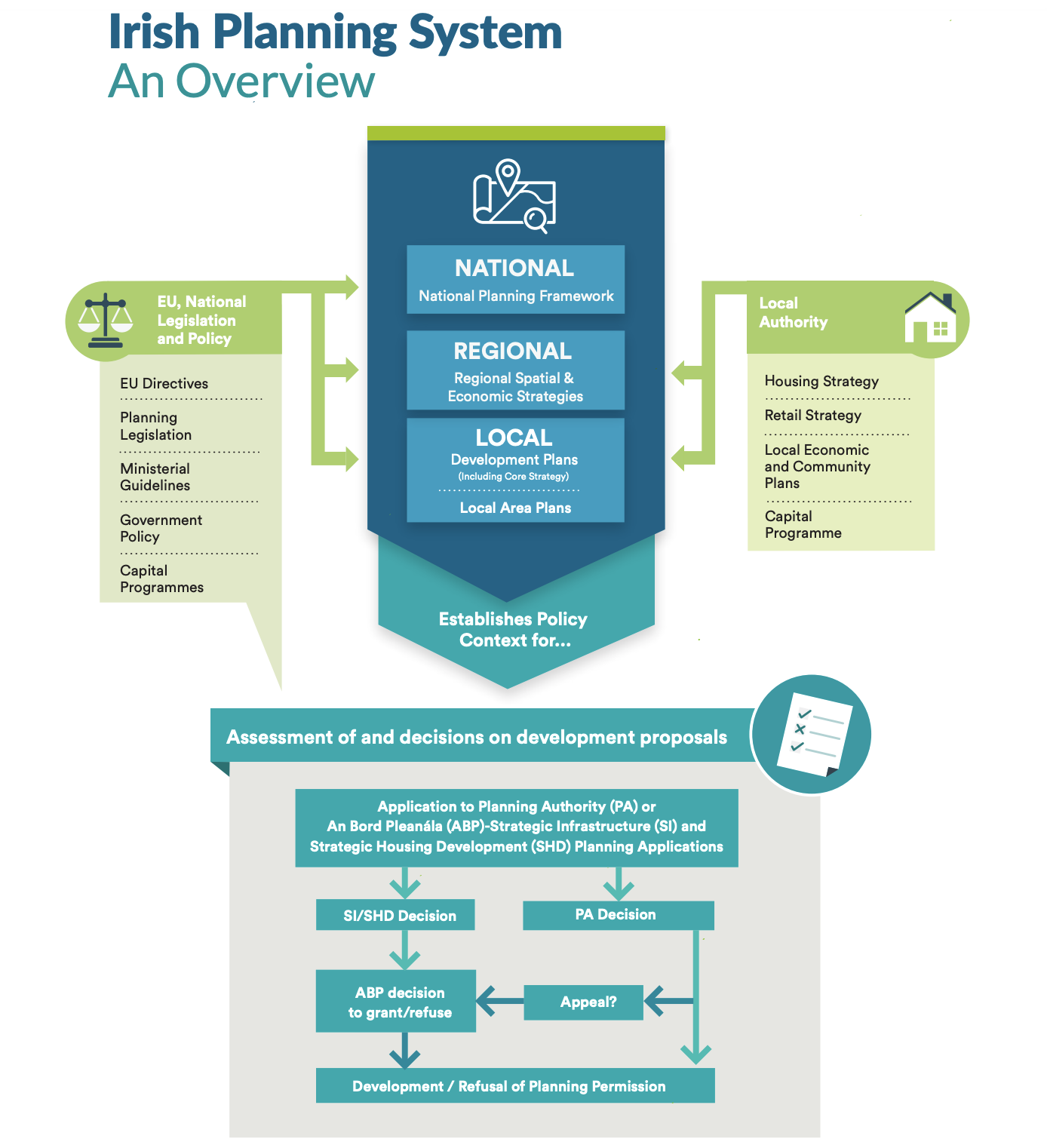
Figure 1.1 Irish Planning System (Source, NPF).
1.3.2 The Regional Spatial and Economic Strategy for the Southern Region (RSES)
The Regional Spatial and Economic Strategy for the Southern Regional Assembly (RSES) was made on the 31st January 2020 and covers the period 2020 - 2026. The RSES identifies employment and population targets for the region which are consistent with the NPF, along with policy objectives to deliver such growth in a sustainable manner in both urban and rural locations. Through its vision statement the RSES seeks to:
- Nurture all our places to realise their full potential.
- Protect, and enhance our environment.
- Work to achieve economic prosperity and improved quality of life for all our citizens.
- Accommodate expanded growth and development in suitable locations; and
- Promote the region’s international reputation as one of Europe’s most creative, innovative, greenest and liveable regions.
The RSES focuses on building critical mass in Waterford City (as well as Limerick and Cork cities), in order to deliver sustainable employment and population growth, and thereby enhance the function of Waterford City as an engine for broader economic growth in the City region. It also sets out a settlement typology.
The area of the RSES and its broad strategic concepts and the spatial expression of the strategy for achieving the vision as they relate to Waterford and County and City, are further detailed in Chapter 2 of Part 1 – Spatial Vision and Core Strategy and Chapter 3 of Part 2 – Waterford City and MASP of Volume 1.
1.3.3 Waterford City
The Waterford Metropolitan Area Strategic Plan (MASP) recognises that Waterford is the largest urban centre in Ireland’s South-East, and the state’s fifth largest city. The vision for the Waterford MASP is to develop a Concentric City, north and south of the river (including areas in County Kilkenny), based on the guiding sustainable growth principles established in the Waterford Planning, Land-use and Transportation Study 2004 – 2020 (PLUTS) - i.e. building critical mass in a compact and balanced city, Integration of land-use and transportation, development of educational resources and a technological university and recognising the city’s people as the heart of the city’s potential. The Waterford MASP has identified a number of strategic goals. These are briefly summarised as:
- Future expansion, growth and ambition for the City will be based on a sustainable place framework and principles.
- Metropolitan areas will be connected through actions which seek to deliver efficient, integrated and sustainable connectivity.
- Waterford City will be an economic engine driving regional economic growth through specialisation and innovation along with relevant infrastructure to deliver and sustain growth.
- A high-quality environment and quality of life, as demonstrated through the Healthy City, a transition to a zero-carbon future and enhanced environmental quality incorporating blue/green infrastructure, a metropolitan area that is creative in terms of its culture, arts and heritage and which fosters an enhanced tourist experience and Metropolitan Scale Regional Amenities with a focus on Waterford Harbour;
- A socially inclusive, multi-cultural metropolitan area with equal opportunities for learning, supported by actions to overcome social exclusion, foster lifelong learning, participation in decision making and targeting initiatives to prioritise regeneration of disadvantaged areas.
- The City will be a platform for implementing best practice, pilot initiatives and innovation, particularly with regard to collaboration, disruptive technologies, climate action, regeneration, compact growth and regeneration projects and monitoring of implementation; and,
- Engage innovative approaches to deliver strategic priorities with particular emphasis on delivery of regeneration/compact growth, and strategic employment/residential development through processes such as active land management, agency type approaches, full integration of land use and transportation planning, and innovative approaches to the Core Strategy
(Note: The ‘7 Goal Criteria’ as set out in Appendix 3 of the RSES have been included and considered in the Core Strategy underpinning this Development Plan).
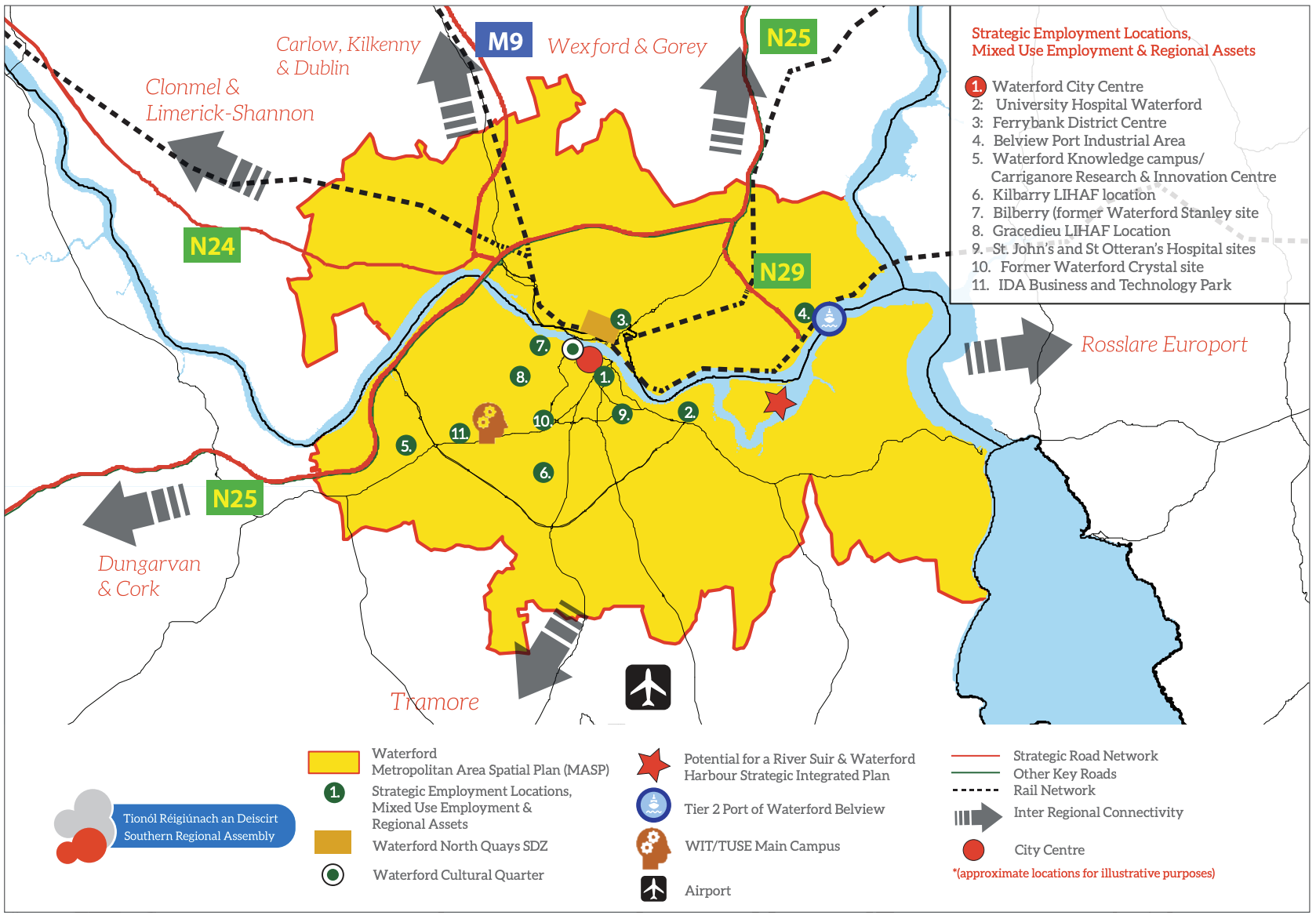
Figure 1.2 Waterford MASP (Source RSES)
Figure 1.2 identifies the broad strategy on which the MASP is based and strategic assets and strengths of Waterford City and its Metropolitan Area. Further details regarding the relevant elements of the MASP are set out in Chapter 3 of Part 2 of Volume 1.
1.3.4 Dungarvan Key Town
The RSES notes that Dungarvan (including Abbeyside and Ballinroad), is a former County Town and an important economic driver for West Waterford. As such Dungarvan is designated as one of 14 Key Towns in the RSES and it plays a critical role in underpinning the RSES and ensuring a consolidated spread of growth beyond the cities to the sub-regional level. The town will be the focus for significant growth (more than 30%) during the period to 2040.
Dungarvan is recognised for its strategic location on the Waterford-Cork N25 transport corridor, as an attractive coastal and harbour town which functions as a tourist centre for the Waterford Greenway and the Gold Coast and as a significant food hub focussing on high quality local produce. The town is a significant location for indigenous industry and Foreign Direct Investment (FDI), with educational and health/community facilities and a vibrant retail and services sector serving the local community and an expanding tourism sector. The town is the Gaeltacht Service Town for the nearby Gaeltacht na nDéise located around An Rinn and An Sean Phobal.
The RSES highlights a number of key attributes in relation to Dungarvan which include its strategic Location on the Waterford – Cork N25 transport corridor and access to ports/airports in Waterford and Cork and Belview Port, Smarter Travel legacy, extensive and diverse employment base, role as a Gaeltacht Service Town servicing Gaeltacht na nDéise, a renewable energy hub, tourist centre for Ireland’s Ancient East & Waterford Greenway with close proximity to the UNESCO Geocoast and other natural and recreational assets and its role in servicing the healthcare needs of West Waterford with St Joseph’s Hospital & Dungarvan District Hospital.
In terms of progressing the future sustainable development of Dungarvan as a Key Town, the RSES contains a specific Regional Policy Objective (RPO 24) in relation to Dungarvan. The Objective is set out below:
- To strengthen the role of Dungarvan as a strategically located urban centre of significant influence in a sub-regional context and in its sub-regional role as a Gaeltacht Service Town, leveraging its strategic location along the Waterford Cork N25 route and to build upon its inherent strengths including historical, cultural and architectural heritage, digital connectivity, skills, innovation and enterprise, tourism (in particular the Waterford Greenway and its potential sustainable expansion), culture and retail services. In respect of its importance to the environment, to tourism, to fishing, and to aquaculture (niche industries supporting rural employment), the RSES supports the environmentally sustainable development and treatment of Dungarvan Harbour and coastline.
- To seek improvements and upgrading of the N25 Waterford to Cork route, the N72 Dungarvan to Mallow and the R672 linking the Key Towns of Clonmel and Dungarvan.
- To support the development of Dungarvan as the Gaeltacht Service Town for Gaeltacht na nDéise.
- To support for enhanced provision of bus services to enable improved intra-regional and inter-regional connectivity to attract more passengers to public transport and away from use of private motor cars.
- To support the continued development of cycling and walking infrastructure as part of Go Dungarvan Smarter Travel Programme and to support the accessibility of the public realm for vulnerable road/ footpath users and persons with disabilities.
- To support the delivery of the infrastructural requirements identified for Dungarvan (including amenities and facilities for the community and voluntary sector) subject to the outcome of the planning process and environmental assessments.
- Support the development of Dungarvan as a subregional centre for education and training, including lifelong learning, by building on existing links with international third-level education providers and WIT; and
- Support investment in flood defence measures.
Through the implementation of Regional Policy Objective 24, the RSES seeks to strengthen this function is terms of growing economic activity and population and providing infrastructure to support this growth; in particular, enhanced placemaking and regeneration of the town centre, improvements to the N25 and N72, upgrades to water and wastewater services, and improvements to sustainable transport modes through provision of a Local Transport Plan for the town. The Development Plan supports these policy objectives which will promote and facilitate the sustainable development of our Key Town.
1.4 Environmental Assessment and Climate Change
In accordance with the provisions of Section 10(1D) of the Planning and Development Act, 2000 (as amended), the Development Plan policies and objectives are consistent, as far as practicable, with the conservation and protection of the environment.
The preparation of the Development Plan has been informed by Strategic Environmental Assessment (Environmental Report Appendix 19), and the Habitats Directive Assessment (Natura Impact Report Appendix 20). Preparation of the Plan has also been informed by a Stage 2 Strategic Flood Risk Assessment (SFRA) (Appendix 13), carried out in accordance with the DOECLG/OPW Guidance ‘Planning System and Flood Risk Management – Guidelines for Planning Authorities’ (2009). The provisions of chapters (1, 2 & 3 of Volume 1, Volume 2, and land use zoning objectives) demonstrate HDA requirements being incorporated into the implementation of Development Plan policy, and any subsequent Plans or Frameworks. More specifically, Natural Heritage Policy in Chapter 9 requires that plans and projects with the potential to have a significant impact, directly or through indirect or cumulative impact, on Natura 2000 sites (SAC, SPA and associated Article 10 habitats), are subject to Habitats Directive Assessment (Appropriate Assessment) under Article 6 of the Habitats Directive (92/43EEC) and associated legislation and guidelines informing decision making.
In terms of compliance with the Water Framework Directive, implications and requirements such as those relating to protecting and enhancing water quality and securing the objectives of the River Basin Management Plan 2018-2021, are evidenced and outlined in Chapter 9. The environmental management policies and objectives are consistent with the District River Basin Management Plan and as such, are deemed compliant in meeting the water quality objectives under the Water Framework Directive.
In addition to our obligations under Section 10(2)(n) of the Planning and Development Act 2000, as amended, which are reflected in the core and settlement strategies in particular, other climate change considerations and measures are included in Chapters 9 and the Development Management Standards in Volume 2, drawing on our Waterford Climate Adaptation Strategy 2019, the National Climate Action Plan 2021, and the Climate Action and Low Carbon (Amendment) Act.
1.5 Structure of the Development Plan
The Development Plan comprises a series of separate, but interrelated elements. The Plan is structured as follows:
- Volume 1: Written Statement consisting of the following:
- Part 1: Vision and Strategy
- Part 2: Waterford City and MASP Policy Objectives
- Part 3: Waterford City & County Policy Objectives
Note: Mapping relating to the land use zoning, specific objectives and other relevant matters are available via our mapping portal [1] .
1.6 UN Agenda 2030: The Development Plan and its Strategic Outcomes
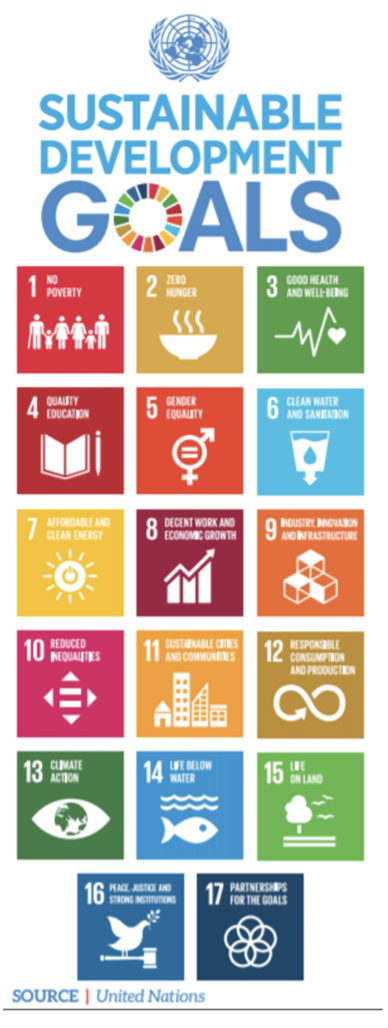
The UN 2030 Agenda is a plan of action for people, the planet and prosperity. The plan sets out 17 Sustainable Development Goals (SDGs) that integrate the three indivisible dimensions of sustainable development - economic, social and environmental. Since 2015, Ireland is a signatory to the UN’s Sustainable Development Goals, and this is heavily reflected throughout the NPF and the RSES.
The European Green Deal is a growth strategy that aims to transform the EU into a fair and prosperous society, with a modern, resource-efficient and competitive economy where there are no net emissions of greenhouse gases in 2050 and where economic growth is decoupled from resource use. It is about improving the well-being of people, making Europe climate neutral and protecting the natural habitat which will be good for people, the planet and the economy. The aims of the Green Deal are: for Europe to become climate-neutral by 2050; to protect human life, animals and plants by cutting pollution; to help companies become world leaders in clean products and technologies; and to help ensure a just and inclusive transition.
The following section sets out 8 Strategic Outcomes which incorporate the overarching objectives of the 17 Sustainable Development Goals of the United Nations’ 2030 Agenda for Sustainable Development, The National Strategic Outcomes as set out in the National Planning Framework and the Regional Strategic Outcomes of the Southern Regions Regional Spatial and Economic Strategy. They detail how the Development Plan will contribute, as practicable, towards their achievement and each chapter is identified by way of the relevant icons employed below in this regard.
Figure 1. 3 UN Sustainable Development Goals
(Source: United Nations)

- To promote development that is compact, diverse sustainable, resilient and adaptive to climate change.
The Development Plan promotes the sustainable compact growth of our city, towns and villages. This type of development will add value and create more attractive places in which people can live and work. All our urban settlements contain many potential development areas, centrally located and frequently publicly owned, that are suitable and capable of re-use to provide appropriate mix of housing, jobs, amenities and services, but which need a streamlined and co-ordinated approach to their development, with investment in enabling infrastructure (nature based solutions) and supporting amenities, to realise their potential. Activating these strategic areas and achieving effective density and consolidation, rather than more sprawl of urban development, is a top priority in facilitating our settlements to become more resilient and adaptive to climate change.

- To support a strong, sustainable, diverse and successful economy underpinned by enterprise, innovation and skills and access to quality education for all.
The Development Plan will facilitate and foster enterprise and innovation which in turn will attract investment and talent. It can be achieved by building the national and regional economic drivers for Waterford as listed in the RSES and by supporting opportunities to diversify and strengthen the economy, to leverage the potential of places. Delivering this outcome will require the coordination of growth and place making with investment in infrastructure, including digital connectivity in skills and talent to support economic competitiveness and enterprise growth.


- To support a sustainable and diverse rural economy and community; to promote sustainable tourism that protects the environment, creates jobs and promotes local culture and products.
The Development Plan will support the provision of services and infrastructure in rural settlements to facilitate appropriate rural economic growth in a sustainable manner. This will be facilitated by the development of enterprise and local economic hubs which will allow for the creation of a wider variety of employment opportunities in rural areas. The plan will also capitalise on local assets, including human, natural and cultural, through improved policy coherence to raise the potential of rural areas and contribute to our local and regional growth as well as developing our tourism and leisure amenities, infrastructure and facilities which support and optimise the attraction of Waterford City and County.

- To support, develop and sustainably strengthen our international, national, regional, local, and neighbourhood connectivity which will enable Waterford to realise its full potential.
The Development Plan promotes public transport connectivity from the national to the local level by supporting accessibility to and between centres of mass and scale and better integration with their surrounding areas. The plan will also facilitate the delivery of public active transport infrastructure and services to meet the needs of neighbourhoods, towns, villages and rural areas in facilitating the “10 minute” city/town/community concept. The Council also promotes the principles included in Design Manual for Urban Streets (2020) for all new developments.

- To provide infrastructure and services in an environmentally sustainable way, which is planned and infrastructure-led and ensures the sustainable management of water, waste and other environmental resources and supports economic development, human well-being and biodiversity gain.
The Development Plan encourages a nature-based infrastructure led approach to development in all our settlements which will contribute to carbon reduction and achieve environmental enhancement and economic growth. It will be necessary to collaborate with infrastructure delivery agencies to facilitate the timely delivery of enabling infrastructure to priority zoned lands in order to deliver planned growth and development.

- To adapt, safeguard and enhance our environment through sustainable development prioritising action on climate change across the region, driving the transition to a low carbon and climate resilient society.
This has been a key consideration in the plan making process and the plan will support measures to build resilience to climate change throughout Waterford to address impact reduction, adaptive capacity, awareness raising and providing for nature-based solutions. We have introduced policies and proposals to both policies and proposals to tackle and cope with climate change.

- To protect, conserve and enhance our unique natural heritage, landscapes, seascapes, biodiversity, built and cultural heritage assets.
The Development Plan incorporates an Ecosystems Services approach for the integrated management of land, water and living resources that promotes conservation and sustainable use in an equitable way. Our policies promote heritage led regeneration to improve the quality of our historic towns and villages for residents and tourists. They also give an appropriate level of protection to internationally, nationally and locally designated sites of built, archaeological and natural heritage importance. The plan seeks to connect areas of green and blue space and habitats such as parks, paths, and woodlands within and on the edge of our villages and towns. These areas can provide a range of social, ecological, and economic benefits. Developments must help to provide these important green links between development sites, the wider countryside, and our urban areas. The Development Plan will protect and promote green-blue networks where they have been created, or there is a firm plan for their establishment, but is unable to promote anything other than aspiration.
The Plan sets out polices to develop Waterford Cultural Quarter as a key enabler for enterprise growth, innovation, regeneration, place-making and community development, health and well-being and support measures under Culture 2025, Creative Ireland Strategy 2017-22 and Action Plan for Rural Development.

- To make places more sustainable, inclusive, diverse, accessible, and safe with the highest standards of design.
The Development Plan promotes attractive, liveable, well designed, accessible and connected places with excellent quality public realm that are home to diverse and integrated communities that enjoy a high quality of life and well-being. Development needs to be proportionate and sympathetic to the needs of the community. We need to achieve excellence in design across all developments in Waterford.
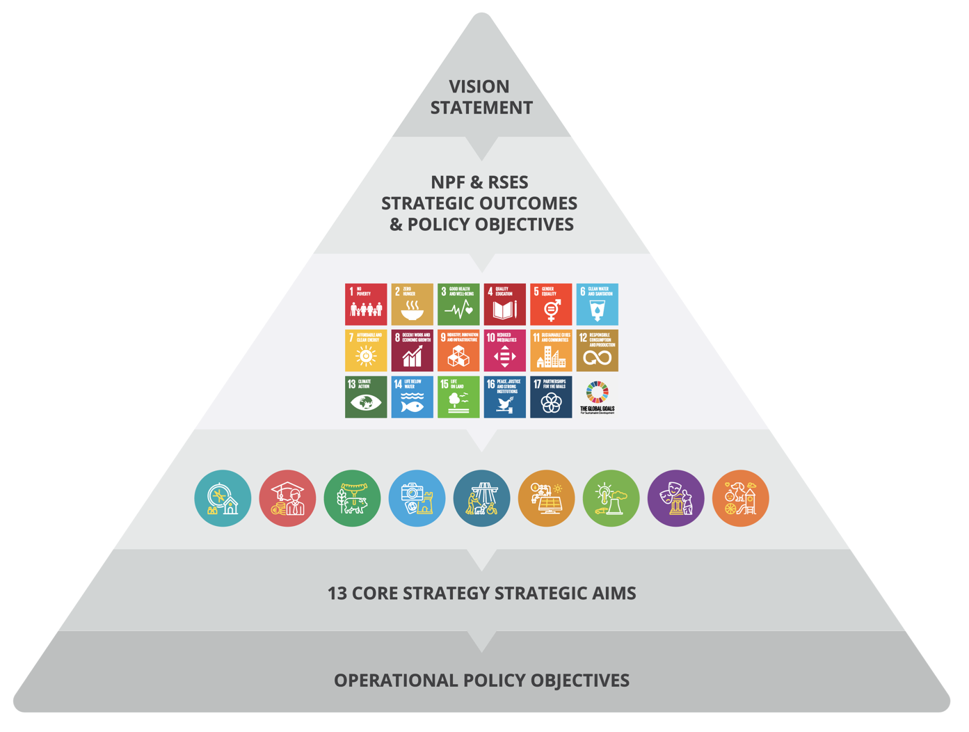
Figure 1. 4 Core Strategy Principles and Strategic Aims
1.7 Informing the Development Plan
Set out below are the principal International, National, Regional and Local Policy Documents, Guidelines and Plans that inform the preparation of the Waterford City and County Development Plan while a compliance statement is set out in Appendix 1.
1.7.1 International Policy and Directives
- UN (1992) The Convention on Biological Diversity (CBD)
- UNESCO (1972) The Convention for the Protection of the World Cultural and Natural Heritage
- Council of Europe (1996) The Pan-European Biological and Landscape Diversity Strategy
- Council of Europe (1996) The European Landscape Convention 2000.
- EU Marine Strategy Framework Directive (MSFD)
- EU The Marine Spatial Planning Directive (MSP)
- EU Water Framework Directive (WFD)
- EU Floods Directive
- EU Strategic Environmental Assessment Directive
- EU Urban Wastewater Treatment Directive
- EU Birds Directive and Habitats Directives
- EU Nitrates Directive
- EU Environmental Noise Directive
- EU Green Infrastructure Strategy
- UN (2015) Paris Agreement
- UN (2015) 2030 Agenda for Sustainable Development (including Sustainable Development Goals)
- EU 2020 and 2030 climate and energy targets as well as longer term 2040 and 2050 milestones and targets
- Covenant of Mayors for Climate and Energy
- Waste Framework Directive
- European Circular Economy Action Plan 2020 – For a cleaner and more competitive Europe – part of the European Green Deal.
1.7.2 National Legislation
- Planning and Development Act and Regulations, 2000 to 2020 (as amended).
- Local Government Reform Act, 2014 (as amended)
- The Maritime Planning and Development Management Bill, 2021
- Water Services Acts, 2007 to 2017
- Protection of the Environment Act, 2003
- Wildlife (Amendment) Act 2000
- Architectural Heritage (National Inventory) and Historic Monuments (Miscellaneous Provisions) Act, 1999
- Heritage Act, 1995
- National Monuments Acts, 1930-1994
- Waste Management Act 1996
- Climate Action and Low Carbon Development Acts 2015 to 2021
1.7.3 National Policy
- Government of Ireland (2020) A Roadmap for Social Inclusion: Ambitions, Goals and Commitments 2020-2025
- Government of Ireland (2019) Housing Options for Our Aging Population
- Government of Ireland (2019) National Student Accommodation Policy
- Government of Ireland (2021) Climate Action Plan to Tackle Climate Breakdown.
- Government of Ireland (2018) Project Ireland 2040 – National Development Plan 2018-2027
- Government of Ireland (2018) Project Ireland 2040 – National Planning Framework
- Government of Ireland (2018) Implementation Roadmap for the National Planning Framework
- Government of Ireland (2018) National Vacant Housing Reuse Strategy 2018-2021
- Government of Ireland (2018) River Basin Management Plan 2018 - 2021
- Government of Ireland (2016) Rebuilding Ireland Action Plan for Housing and Homelessness
- Government of Ireland (2010) The National Renewable Energy Action Plan
- DHPLG (2019) Draft Revised Wind Energy Development Guidelines
- DHPLG (2018) Urban Development and Building Heights: Guidelines for Planning Authorities
- DHPLG (2018) Guidelines for Local Authorities and An Bord Pleanála on Carrying Out Environmental Impact Assessments
- DHPLG (2018) Draft Water Services Guidelines for Planning Authorities
- DHPLG (2017) Part V of the Planning and Development Act: Guidelines
- DHPCLG (2017) Interim Guidelines for Planning Authorities on Statutory Plans Renewable Energy and Climate Change
- DHPLG (2016) Strategy for the Rental Sector
- DECLG (2015) Sustainable Urban Housing, Design Standards for New Apartments: Guidelines for Planning Authorities
- DECLG (2014) Social Housing Strategy 2020: Support, Supply and Reform
- DECLG (2013) Homelessness Policy Statement
- DECLG (2012) A Resource Opportunity – Waste Management Policy in Ireland
- DECLG (2012) Our Sustainable Future – A Framework for Sustainable Development for Ireland
- DECLG (2011) Managing Unfinished Housing Developments Guidance Manual
- DECLG (2011) National Housing Strategy for People with a Disability 2011-2016
- DECLG (2011) Drainage and Reclamation of Wetlands: Draft Guidelines for Planning Authorities
- DEHLG (2007) National Climate Change Strategy 2007-2012
- DCENR (2013) National Digital Strategy for Ireland
- Housing Agency (2019) Designing Housing to Meet the Needs of All
- Housing Agency (2018) Rebuilding the Irish Neighbourhood
- Housing Agency and Urban Agency (2018) Quality Apartments and Urban Housing
- DCYA (2019) Better Outcomes, Brighter Futures: The National Policy Framework for Children and Young People, 2014-2020
- DTTaS (2019) National Sports Policy 2018 - 2027
- DCCAE (2018) National Adaptation Framework: Planning for a Climate Resilient Ireland
- DCCAE (2017) National Mitigation Plan 2017
- DCCAE (2017) Energy Efficiency Action Plan for Ireland #4 2017-2020
- DCCAE (2016) Our Sustainable Future Progress Report 2015
- DOH (2016) Obesity Policy and Action Plan - A Healthy Weight for Ireland
- DoTTS, DoH (2016) National Physical Activity Plan
- DCENR (2015) Ireland's Transition to a Low Carbon Energy Future
- Irish Water (2015) Water Services Strategic Plan
- DAHG (2014) National Landscape Strategy for Ireland
- DOH (2013) National Physical Activity Plan – Get Ireland Active
- DOH (2013) National Positive Aging Strategy
- DCENR (2012) Renewable Energy Strategy 2012-2020
- DoT (2012) Smarter Travel: A New Transport Policy for Ireland 2009-2020
- DoT (2012) Traffic Management Guidelines
- NDA (2012) Building for Everyone: A Universal Design Approach
- NDA and DAHG (2011) Access: Improving the Accessibility of Historic Buildings and Places
- NTA (2011) National Cycle Manual
- DoT (2009) - National Cycle Policy Framework
- DEHLG, DES (2008) The Provision of Schools and the Planning System: A Code of Practice
- DEHLG (2007) Development Plans DEHLG (2005) - Sustainable Rural Housing
- NDA (2004) National Disability Strategy
- DAHGI (2002) National Heritage Plan
- DEHLG (2003) Architectural Heritage: Protection for Places of Public Worship: Guidelines for Planning Authorities
- DHPLG (2019) National Marine Planning Framework (Consultation Draft)
- Department of the Environment, Climate and Communications (2021) - Climate Action Plan 2021 – Securing our Future and associated Sectoral Adaptation Plans
- Department of Housing, Local Government and Heritage (2021) - Housing for All – a New Housing Plan for Ireland.
- Department of Housing, Local Government and Heritage (2022) - Nature-based Solutions to the Management of Rainwater and Surface Water Runoff in Urban Areas, Water Sensitive Urban Design Best Practice Interim Guidance Document
1.7.4 Section 28 Ministerial Guidelines
Section 28 of the Planning and Development Act, 2000 (as amended) states that the Minister may issue guidelines to planning authorities regarding any of their functions under this Act and planning authorities shall have regard to those guidelines in the performance of their functions.
Every Planning Authority is required consider the policies and objectives of the Minister contained in the guidelines when preparing and making the draft Development Plan and the Development Plan and to append a statement to the draft Development Plan and the Development Plan which demonstrates the following:
- How the planning authority has implemented the policies and objectives of the Minister contained in the guidelines when considering their application to the area or part of the area of the Development Plan, or
- If applicable, that the planning authority has formed the opinion that it is not possible, because of the nature and characteristics of the area or part of the area of the Development Plan, to implement certain policies and objectives of the Minister contained in the guidelines when considering the application of those policies in the area or part of the area of the Development Plan and shall give reasons for the forming of the opinion and why policies and objectives of the Minister have not been so implemented.
The following is a list of all currently applicable Ministerial Planning Guidelines issued under Section 28 of the Act:
- Tree Preservation – Guidelines for Planning Authorities
- Telecommunications Antennae and Support Structures – Guidelines for Planning Authorities (1996)
- Strategic Environmental Assessment (SEA) Guidelines (2004)
- Quarries and Ancillary Activities (2004)
- Sustainable Rural Housing Guidelines (2005)
- Development Management Guidelines (2007)
- Development Plan – Guidelines for Planning Authorities (2007)
- Draft Development Plan Guidelines for Planning Authorities (2021)
- Quality Housing for Sustainable Communities – Design Guidelines (2007)
- Provision of Schools and the Planning System (2008)
- Appropriate Assessment of Plans and Projects in Ireland – Guidance for Planning Authorities (2009)
- The Planning System and Flood Risk Management – Guidelines for Planning Authorities (2009)
- Sustainable Residential Development in Urban Areas (Cities, Town and Villages): Guidelines for Planning Authorities (2009)
- Guidance Note on Core Strategies (2010)
- Implementing Regional Planning Guidelines – Best Practice Guidance (2010)
- Architectural Heritage Protection – Guidelines for Planning Authorities (2004), as updated (2011)
- Retail Planning Guidelines for Planning Authorities (2012)
- Spatial Planning and National Roads Guidelines (2012)
- Guidelines for Planning Authorities on Section 261A of the Planning and Development Act, 2000 and Related Provisions (2012) as updated (July 2012)
- Development Contribution Schemes – Guidelines for Planning Authorities (2013)
- Local Area Plans – Guidelines for Planning Authorities (2013)
- National Landscape Strategy for Ireland 2015-2025
- Childcare Facilities: Guidelines for Planning Authorities (2001) as updated by Circular letter PL3/2016 (2016)
- Interim Guidelines for Planning Authorities on Statutory Plans, Renewable Energy and Climate Change (2017)
- Part V of the Planning and Development Act 2000 (2017)
- Urban Development and Building Heights – Guidelines for Planning Authorities (2018)
- Guidelines for Planning Authorities and An Bord Pleanála on carrying out Environmental Impact Assessment (2013), as updated (2018)
- Sustainable Urban Housing Design Standards for New Apartments (2015), as updated (2018)
- Wind Energy Development Guidelines (2006 and draft 2019)
- Design Manual for Urban Roads and Streets (2013) as updated in 2020
- Housing Supply Target Methodology for Development Planning 2020
- New Strategy of an tÚdarás 2021-2025
1.7.5 Regional Plans and Policy
- SRA (2020) Regional Spatial and Economic Strategy 2020-2032
- Southern Region Waste Management Plan 2015-2021 and its successor.
Note: This list is not exhaustive and additional documents will help inform and guides the preparation of the City and County Development Plan. A full list of the acronyms for the bodies referred to above along with their full titles is provided below. In the interests of clarity, the list indicates whether the title of the relevant Government Department is currently in use, or whether it has been superseded.
DAHG: Department of Arts, Heritage and the Gaeltacht (superseded)
DAHGI: Department of Arts, Heritage, Gaeltacht and the Islands (superseded)
DBEI: Department for Business, Enterprise and Innovation (in use)
DCCAE: Department of Communications, Climate Action and Environment (in use)
DCENR: Department of Communications, Energy and Natural Resources (superseded)
DCYA: Department of Children and Youth Affairs (in use)
DECLG: Department of the Environment, Community and Local Government (superseded)
DEHLG: Department of the Environment, Heritage and Local Government (superseded)
DELG: Department of the Environment and Local Government s (superseded)
DES: Department of Education (in use)
DHPCLG: Department of Housing, Planning, Community and Local Government (superseded) DHPLG Department of Housing, Planning and Local Government (in use)
DOE: Department of the Environment s (superseded) DOH: Department of Health (in use)
DOT: Department of Transport (superseded)
DRHE: Dublin Regional Homeless Executive
DTTaS: Department of Transport, Tourism and Sport (in use)
EU: European Union
NDA: National Disability Authority (in use)
NTA: National Transport Authority (in use)
UCD: University College Dublin
UN: United Nations
UNESCO: United Nations Educational, Scientific and Cultural Organisation
